Part I: Sailing to the South Seas
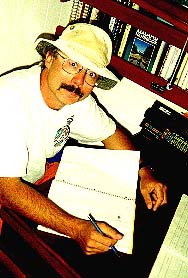 By Marc Edge
In 1995 I set sail aboard my 40-foot Mason-designed ketch, Markenurh
-- a North American Indian word of the Kwagiulth band meaning Killer Whale
-- on a voyage of discovery. I had taken "early" retirement two years previously
from my job as a reporter for the morning Province newspaper in
Vancouver, Canada. I say early because most people think I was a bit young
to "retire" at age 38. But I had a dream to sail to the South Pacific and
visit New Zealand. When the Province decided to downsize in 1993, I jumped
at the chance to collect 16 years of severance pay. That was enough to
pay off my boat and outfit her with the gear needed for a major ocean voyage.
I figured I had enough to keep me going for a couple of years. Hopefully
I would be able to find work on a newspaper in New Zealand and be able
to keep the voyage going -- on to Australia and maybe across the Indian
Ocean to South Africa. But that was getting a bit ahead of the game. I
set my sights on New Zealand first. I could always come back from there
within my two-year timeframe.
North to Alaska
From Vancouver we first headed north on a shakedown cruise to
the icefields of Alaska's Glacier Bay in June with a crew of four. First
to sign on was Bob, whom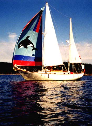 I'd met in San Francisco at a "crew" party hosted by Latitude 38,
the local sailing magazine. Then I saw a notice on the marina bulletin
board from Michael, a recent engineering graduate from Queen's Univesity
in eastern Canada, who was also a certified sailing instructor. We were
about to set sail north, the three of us, when a friend of mine pointed
out a classified ad in a local weekly magazine. "Teach Me to Sail," read
the ad from 20-year-old Andrea, of suburban White Rock. I called her up.
I'd love to teach you to sail, I said, but we're heading to Alaska in two
weeks. "I'd love to sail to Alaska," she replied, "but I've got a summer
job working on the ferries." Well, guess what? The job fell through and
off she came with us to Alaska. I put Michael in charge of her instruction.
They became...more than friends.
I'd met in San Francisco at a "crew" party hosted by Latitude 38,
the local sailing magazine. Then I saw a notice on the marina bulletin
board from Michael, a recent engineering graduate from Queen's Univesity
in eastern Canada, who was also a certified sailing instructor. We were
about to set sail north, the three of us, when a friend of mine pointed
out a classified ad in a local weekly magazine. "Teach Me to Sail," read
the ad from 20-year-old Andrea, of suburban White Rock. I called her up.
I'd love to teach you to sail, I said, but we're heading to Alaska in two
weeks. "I'd love to sail to Alaska," she replied, "but I've got a summer
job working on the ferries." Well, guess what? The job fell through and
off she came with us to Alaska. I put Michael in charge of her instruction.
They became...more than friends.
We had a permit to visit Glacier Bay National Park for six days beginning at the end of June, so we left June 4. Usually the wind is from the northwest, but this summer was different, with southerly winds prevailing. That was fine with us as we could sail most of the way instead of listening to the disel engine drone. We harbor-hopped through scenic Desolation Sound, Johnstone Strait and on up the coast to Prince Rupert. From there it was a day sail to Ketchikan, and we were finally in Alaska! There were plenty of salmon to be had from the friendly Alaskan fishermen, and we even pulled in a halibut while at anchor! There were also several close sightings of whales, mostly humpbacks. Too bad we didn't see many orca, our namesake.
Once in Glacier Bay, we were in for a treat in terms of spectacular scenery. We had picked up a tourist in Alaska, a kayaker from Lubbock, Texas named Randall Billings, who was an optometrist back home. Randall had a video camera and captured it all on tape for us to treasure. The glaciers were spectacular! We were able to anchor just a mile from one of them -- Reid Glacier. In the night, we could hear the thunderous CRACK! as a piece of ice would "calve" off with a giant splash. We hiked on the glacier, and I was even able to get inside it! On our way back from Alaska, we visited the haunting Queen Charlotte Islands, with their weathered totem poles, and cruised down the west coast of rugged Vancouver Island. Returning to home port Aug. 15, we did some necessary repairs and outfitting and on October 1 left for warmer waters.
Markenurh Sails South
My Alaska crew had scattered, so I recruited two Frenchmen, Marco and Jean-Luc for the trip to San Francisco, where I was confident of finding more crew. First stop was Washington state's Puget Sound, where we stopped at Anacortes to pick up some gear, then headed out the Strait of Juan de Fuca, stopping at Port Angeles and Neah Bay before rounding Cape Flattery into the open Pacific. After three days of steady southward progress, the weather forecast on the VHF radio was for southerly gales, so we stopped at Newport, Oregon with a little help from the Coast Guard for our late-night crossing of the choppy "bar" at the harbor's entrance. Newport wasn't such a bad place to lay over, because the marina is right next to the Rogue Brewery, where we were regulars at the afternoon tasting tours. After three days in Newport waiting for fair weather, we caught a brisk northwesterly under sunny skies and set out for San Francisco. First we had 20 knots of winds and 10-foot seas -- fairly brisk going. But the winds and seas both built and soon we had 30 knots of winds and 15-foot seas. Lucikly the waves were from astern, so they were at least pushing us in the right direction! Each wave would pick us up and we would ride high on its crest, then fall back into the trough until the next wave would pick us up. We were truly SURFING U.S.A.!
As we got to California, the action picked up even more. The wind speed was into the 40s -- we recorded one gust at 52 knots! There were only two of us, myself and Marco, since Jean-Luc had left us in Newport. We were hand steering, and trying to keep pointed in the right direction with these giant waves coming up behind us and leaving us in their wake took all our energy. But finally we arrived in San Francisco, fought our way through the current under the fabled Golden Gate bridge and dropped anchor in picturesque Aquatic Park, right in the middle of downtown 'Frisco! After a few days we headed across the bay to sleepy Sausalito.
From the Bay area we set off again into open ocean. Marco stayed behind -- he'd found a girlfriend in San Francisco. But in his place I had three excellent crew -- Jeff, Kevin and Stacy. Stacy was a gourmet chef from Australia, Kevin was a diesel mechanic and certified yacht hand from South Africa, and Jeff was a Lebanese-American who had worked on boats in Alaska and was keen to learn about sailing. By this time, the seas had calmed down considerably and we day-sailed down the coast, stopping first at the pretty seaside town of Santa Cruz. Luckily we'd met Robbin in San Francisco. She was from Santa Cruz and worked as an engineer in San Francisco during the week. But on the weekends she went home, so we met her there and she showed us around town. From there we went to San Luis Obispo, where we could see William Randolph Hearst's famous castle high up on the hill at San Simeon. Then we set off for a cruise through the offshore Channel Islands, so barren as to be moon-like.
From Avalon Harbor on Catalina Island, the largest and most southerly of the Channel Islands, we headed for the major resupply port of San Diego. We'd heard a lot about the San Diego Harbor police and how they made life unpleasant for cruisers, but they couldn't have been nicer to us! I think they were trying to overcome a lot of bad publicity they'd had in Latitude 38. After loading up with provisions -- and a couple of new solar panels to keep the batteries charged up -- we headed south again with Mexican visas in hand.
Mexican Siesta
Stacy had flown back to work in Vancouver from San Diego as planned, but I hadn't counted on losing Kevin, who phoned home to Durban from San Diego and learned of a job offer he couldn't pass up. Luckily I'd made contact with Lee through her ad in Latitude 38 back in San Francisco, and she flew down and joined us for the sail south. Our first stop in Mexico was just south of the border -- Ensenada. Here was where I got my first taste of Mexican paperwork. I was prepared, with six or seven copies of the crew list, boat registration, passports and visas for all the crew. First I went to customs -- none of the crew were allowed ashore until I, as captain, had completed formalities. From the customs office, I next had to visit the port captain. Wouldn't you know it -- his office was on the other side of town! Then I had to visit the immigration office. You guessed -- back across town again. This pattern would be repeated again and again in every Mexican port we visited. Luckily, though, the offices were usually in at least the same area, if not the same building. From Ensenada we began the long trek down the barren desert-like Baja peninsula. . We stopped only once before getting to Cabo San Lucas on the Baja's southern tip. It was almost Christmas by then, and ccccold! We had Christmas dinner at the home of Phil Boston, owner of the cruiser's club, a cantina called the Broken Surfboard. Phil, from Edmonton, Canada, of all places, took good care of us cruisers and had a wall at the Broken Surfboard where he would record the name of each boat that checked in. Lee left us there as it turned out she not only got seriously seasick, but had hardly any money .
On our way to the mainland of Mexico, we stopped at the bird sanctuary island of Isla Isabella. From there we set sail to a landfall at San Blas, where we met up with the famous biting no-seeums. Then it was on to Puerto Vallarta, where I was to meet my friend from Vancouver, Maurice, and a woman from Victoria, Canada I had contacted through her ad on the bulletin board of the Broken Surfboard. Sylvia was interested in doing the trip all the way to New Zealand and just by coincidence was going to be in Puerto Vallarta at the same time as Maurice. I pushed up my itinerary to meet them both, bypassing such ports as La Paz and Mazatlan. When I met Maurice by the pool at his hotel, he said "here's someone you're looking for." It was Sylvia. What a coincidence! They had already met. I kept the boat at Marina Vallarta, just north of the city, where we stayed for two months, provisioning and preparing the boat for the ocean cruise to French Polynesia. Groceries were really cheap in Mexico, as the peso had recently been devalued. By the time we left we were floating well above our normal waterline. Marina Vallarta was a nice place to pass the winter, with lots of cruisers around. We had regular meetings of the "fleet" at the local cruiser's club. This one was at a restaurant called Time Changers run by a couple of former cruisers named Joanie and Dave. The name of their cantina came from the name of their boat.
Sylvia rejoined us in March and we cruised down the coast for a couple
of weeks, showing her the ropes. Jeff decided to travel inland for the
winter, then return to work in Alaska. He got seasick, too. I found another
crew in the newsletter of my cruising club, the Bluewater Cruising Association.
Adrian was a French-Canadian who was also interested in going to New Zealand
with me. We got as far south as Las Hadas, near Manzanillo, a very pretty
resort where the movie '10' was filmed. On our way back up to Puerto Vallarta,
where we planned to leave from, we stopped at San Patricio de Melaque.
It just happened to be St. Patrick's Day, so there was a wild party in
town. Back in Puerto Vallarta, we did some last minute grocery shopping
and on April 4, 1996 sailed out of Banderas Bay, headed across the Pacific.
Sailing to the South Pacific
One thing I hadn't counted on in the open Pacific was such a sense
of community -- a radio community. Every morning
we would tune in to the "net" on the high-frequency Single-Sideband
radio and get weather information and talk with other cruisers. I was glad
I'd studied for and passed the test to get my Amateur radio licence back
home in Vancouver. We actually got to know some of our closest fellow cruisers
on a sub-net we would tune into after the main Westbound net, which stretched
from Mexico to Tahiti. We would go off onto another frequency with six
or seven other nearby boats and trade information and stories. It was moral
support as much as anything. I got to know some of the other cruisers pretty
well over the radio before I ever met them in person.
After a while, things settle into a rythym at sea. We kept four-hour watches which meant the three of us each had two watches a day, at the same time each day. After a four-hour watch, we would each get eight hours off, which left lots of time for catching some sleep. But there was lots to do, what with cooking, engine maintenance and everything else you need to do on-board. As radio operator, I took the early-morning watch, plotting the positions and weather reported by each boat that checked into the net. When we started off we were last on the list, of course, and it was heartening to see our progress in how we moved up the list as boats ahead of us reached their destination and others left after us. Unfortunately, some boats left too late and got caught in an early-season hurricane. Brothers Chuck and Leonard about their catamaran Solar Wind were lost, which was a bit of a wakeup call to the rest of us to remember what can happen out there.
After about two days of motoring from Puerto Vallarta, we caught the westerly trades and rode them nicely, wing and wing. That means we went straight down-wind, with the main sail on one side of the boat, fastened tightly to the toe rail with a "preventer" block and tackle to keep it from "jibing" across to the other side of the boat, and the foresail "poled" out on the other side. The reaching pole I had came with the boat and was nothing more than a piece of galvanized pie with a fitting on one end to attach it to the mast and a bolt on the other to put through the clew of the foresail. I at least put two proper spinnaker-pole end fittings on it, but in between was still just a piece of galvanized pipe. Sometimes, rocking and rolling in the waves, the foresail would get "back-winded" and the pipe would bend with a great "wow" in the middle. Then, one particularly boisterous day I was asleep in my forward cabin when the crew began to stomp and shout on deck over top of my head. The pole had bent in the middle and was wrapped 90 degrees around the forestay! We finally struggled it down, but after that we couldn't go wing and wing again until we got a new piece of pipe in Tahiti. That meant we couldn't make a course directly for our destination, and with the waves, our wind-steering vane wasn't able to keep us pointed as far down-wind as we wanted. As a result, our progress was slowed considerably.
One decision we had to make was where to cross the equator. There's no problem with the equator as such, it's just an imaginary line. But a few degrees north of the equator is a climatic zone called the Inter-Tropical Convergence Zone (ITCZ) or "doldrums." That's the area between the northwesterly trades that prevail in the northern hemisphere, and the southeasterly trades you find south of the equator. But far from being the doldrums, sometimes the ITCZ can be quite boisterous, usually a night when there are frequent squalls and lightning as the two air masses -- north and south -- rub up against each other. Mostly we motored through them, and it took two days. We decided to head down Longitude 125 West through the ITCZ to the SE trades. But when we finally got there, the wind was more from the east, which meant we had tio try and go as far downwind as possible. That was hard without our reaching pole, and I ended up wishing we'd gone a bit farther before we crossed the equator, like about 130 West.
But finally we made it, with the help of our trusty Global Positioning System (GPS) receiver, 25 days and 18 hours after departure we sighted the high, volcanic island of Hiva Oa in the morning light, right where it should have been.
 French Polynesian Paradise
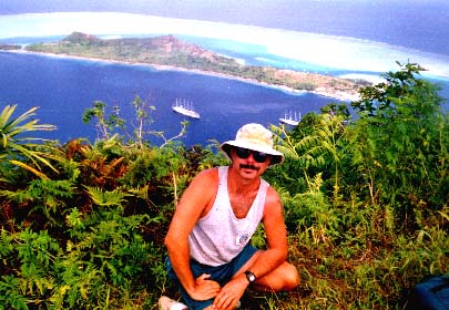
Hiva Oa is in the Marquesas group of islands, the most easterly of the islands of French Polynesia, and therefore the closest to North America. The Marquesas are young, high islands, lush in vegetation. Most do not yet have a coral reef developed around them like other volcanic islands, which gradually recede into the ocean as they cool, leaving just their coral reef behind. Atuona was our first landfall harbor. It is a small Polynesian town without many amenities. The people are Polynesian but the administration is French, with gendarmes keeping track of the yachties as they check in and out. We spent about a week resting and relaxing and seeing a few sights around Atuona. We didn't do much in the way of provisioning as the prices were very high. A can of beer was about $3 U.S., which was a change from Mexico, where that was about the price of a six-pack. From Atuona we went to the small island of Oa Pou nearby. It has spectacular scenery, with jagged "pinnacle" mountains jutting out of the island. We spent a few days there, and Sylvia met a tall, dark, handsome Frenchman named Michel who was visiting from Tahiti. She took his phone number and promised to call when we got there. Next we went to Nuku Hiva, the main island in the Marquesas. We hiked to the waterfall from Daniel's Bay and were feasted on by the ravenous no-seeums, the scarred bites of which we would be scratching for months to come.
Next it was on to the Tuamotus group, which is a series of low-lying coral atolls. This is where the power of GPS really came in handy. A satellite navigational system developed for the U.S. military, it is downgraded for civilian use. While the military can guide a bomb to within inches of its target using GPS, we could only pin-point our position within 50 yards. That was more than accurate enough, though, to find the passes into the lagoons of several of the Tuamous, including spectacular Rangiroa, where snorkelling was like being in a big aquarium of tropical fish. But like all sailors, we longed for legendary Tahiti, which was actually discovered by an ancestor of mine, Samuel Wallis, in 1767. That made it even more special for me. While we were in Rangiroa, the wind was howling at 40 knots outside, so we waited for it to die down before we set off on the 500-mile passage to Tahiti. But a day after we left, the wind had died off completely and we had to motor the rest of the way. We almost made it, too. We were about three miles off the harbor entrance at Papeete and calculated we'd make it just by sunset. Then the engine sputtered and died. We were out of fuel! Luckily, we were able to call one of our friends on the VHF radio, and he came out in his dinghy with a jerry can of diesel and we motored into Papeete harbor somewhat sheepishly.
After anchoring overnight, we tied stern-to the yacht quai the next day. We were right downtown Tahiti, with cars whizzing past and everything. We spent a month there because all the jobs had piled up and we were finally somewhere we could get supplies. My high school French came in handy and I got to know the town well by tromping the streets in search of hardware. I also got myself a permanent souvenier -- a tatoo. Tatoo is actually a Tahitian word, as that is where they originated, Many sailors brought them back from a voyage there, so I decided I should, too. I got one done by a young Marquesan, who are the best tatooists. It's a Polynesian rendition of a Kwagiulth Markenurh.
One problem I had was crew, as it was apparent that Adrian left something to be desired as a helmsman. The difficulty was that he would instinctively turn the wheel the wrong way! I told him we needed to find someone who could steer and he took the hint, finding another boat that needed crew. I got lucky when John walked down the quai and saw my CREW WANTED sign. He had just stepped off a plane from Vancouver, of all places, after quitting his job as a real estate developer, selling his house and two cars and getting away from it all. He sounded keen on joining the crew and said he'd be back the next day. When he didn't show up, we figured he'd found a better deal, because I ask crew to share the expenses of the voyage, while lots of other skippers by then were offering free rides or even paying crew. I couldn't afford to do that, however, and figured we'd lost John. But two days later he showed up, all bruised and covered in cuts. He'd been attacked by some natives while hiking. They robbed him of his money, camera and passport and given him a good scare. The Tahitians were not very friendly while we were there, mostly because of the underwater atomic testing being done in the southern Tuamotus. If you were white, they assumed you were French. It was only when you convinced them you weren't French and didn't like the French either that they would warm up to you.
I also met an electrician on the quai named Nate. He was from Los Angeles, where he worked at Marina Del Rey. He had come across on a Mason 54 he had installed about $25,000 worth of electronic gear on. He was supposed to fly back when the owner's family flew in, but found he rather liked Tahiti. I told him I had room on board Markenurh, not to mention lots of electrical problems. He moved in and was with us for the next two months as we cruised the Society Islands, fixing lots of my wiring woes. Next stop was majestic Moorea, the fabled Bali Hai, just 20 miles away. Nate had met a native who invited us for a feast. We anchored on a coral reef, which made for great snorkelling. We hiked up the mountain to the lookout and had a great time. Then it was on to the windward islands, Huahine, Raiatea and fabled Bora Bora, said to be the world's most beautiful island. Bora Bora was my favorite. The crew, especially John and Sylvia, were keen hikers, so we climbed to the top of one of Bora Bora's towering twin peaks. It was exhausting, but the view was spectacular! We didn't want to leave, but our visas were expiring. Before we left, however, Sylvia gave me some bad news. Michel had decided to sail with an English boat that was going the other way -- to Chile -- and she was going to join them. She said she'd come along with us to the Cook Islands, five days sail away, and fly back from there. Hopefully we could find more crew there and continue the voyage on downwind to New Zealand.
What happened in the Cook Islands? Did Markenurh and her intrepid
crew make it to New Zealand? I'm afraid you'll have to call up Part
II for the end of the story.